Clark Reservation State Park Hiking Trails
Jamesville, NY • Scenic Views & Glacial Geology
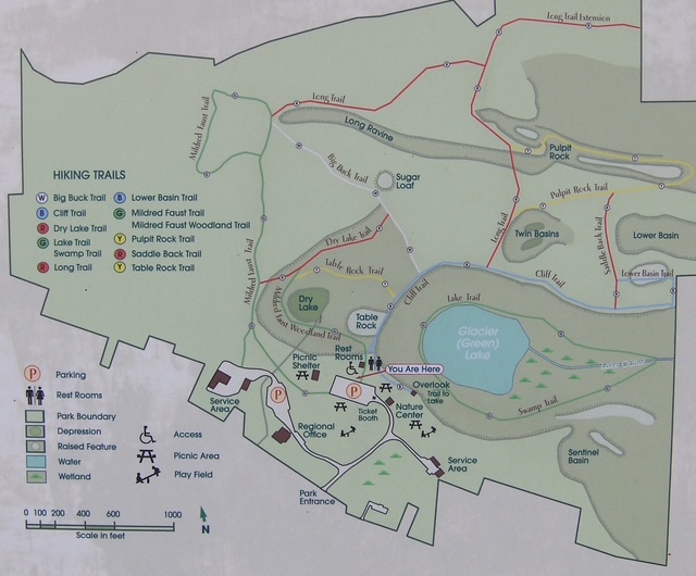
Clark Reservation State Park Hiking Trails Guide
Clark Reservation State Park, located just south of Syracuse in Jamesville, is a hidden gem for hikers. The park protects a dramatic glacial landscape featuring steep cliffs, a rare meromictic kettle lake (Glacier Lake), and rich woodlands. The trail system offers everything from easy nature walks to moderate hikes with rewarding views.
Trails are generally well-marked. Total trail network is roughly 5–6 miles with many loop options. Pets are allowed on leashes.
Main Trails at Clark Reservation
Cliff Trail
Length: 0.6 miles (plus 0.1-mile extension)
Difficulty: Moderate (some rock scrambling)
Highlights: Dramatic cliff-edge views 175+ feet above Glacier Lake, excellent photography spots, and birdwatching.
Lake Trail
Length: 0.6 miles
Difficulty: Moderate to challenging (can be wet)
Highlights: Close-up views of the unusual meromictic lake. Often requires some rock-hopping after rain.
Mildred Faust Trail
Length: 0.7 miles (longest trail in the park)
Difficulty: Easy to moderate
Highlights: Botanical focus with many fern species. Named after a local botanist.
Pulpit Rock Trail
Length: 0.6 miles
Difficulty: Moderate (steep sections)
Highlights: Interesting rock formations and elevated views.
Long Trail
Length: 0.5 miles (+ 0.3-mile extension)
Difficulty: Moderate
Highlights: Quieter woodland walk passing an old stone wall.
Other Trails & Tips
- Big Buck Trail, Dry Lake Trail, Swamp Trail – Shorter connectors that create nice loop options.
- Best loop: Combine Cliff Trail + Lake Trail + Mildred Faust Trail (≈2–3 miles).
- Winter hiking is popular but use caution on icy cliffs.
- Download offline maps via AllTrails or Avenza before visiting.
Park Address: 6100 E Seneca Turnpike, Jamesville, NY 13078